Friday, October 19, 2012

Saint Honorat

Friday 25 May 2012 Continued

The city of Cannes was crazy busy due to it being the last day of the famous Cannes Film Festival.  No, we didn't see any famous people, just got caught in a lot of traffic.

Banner for the Festival

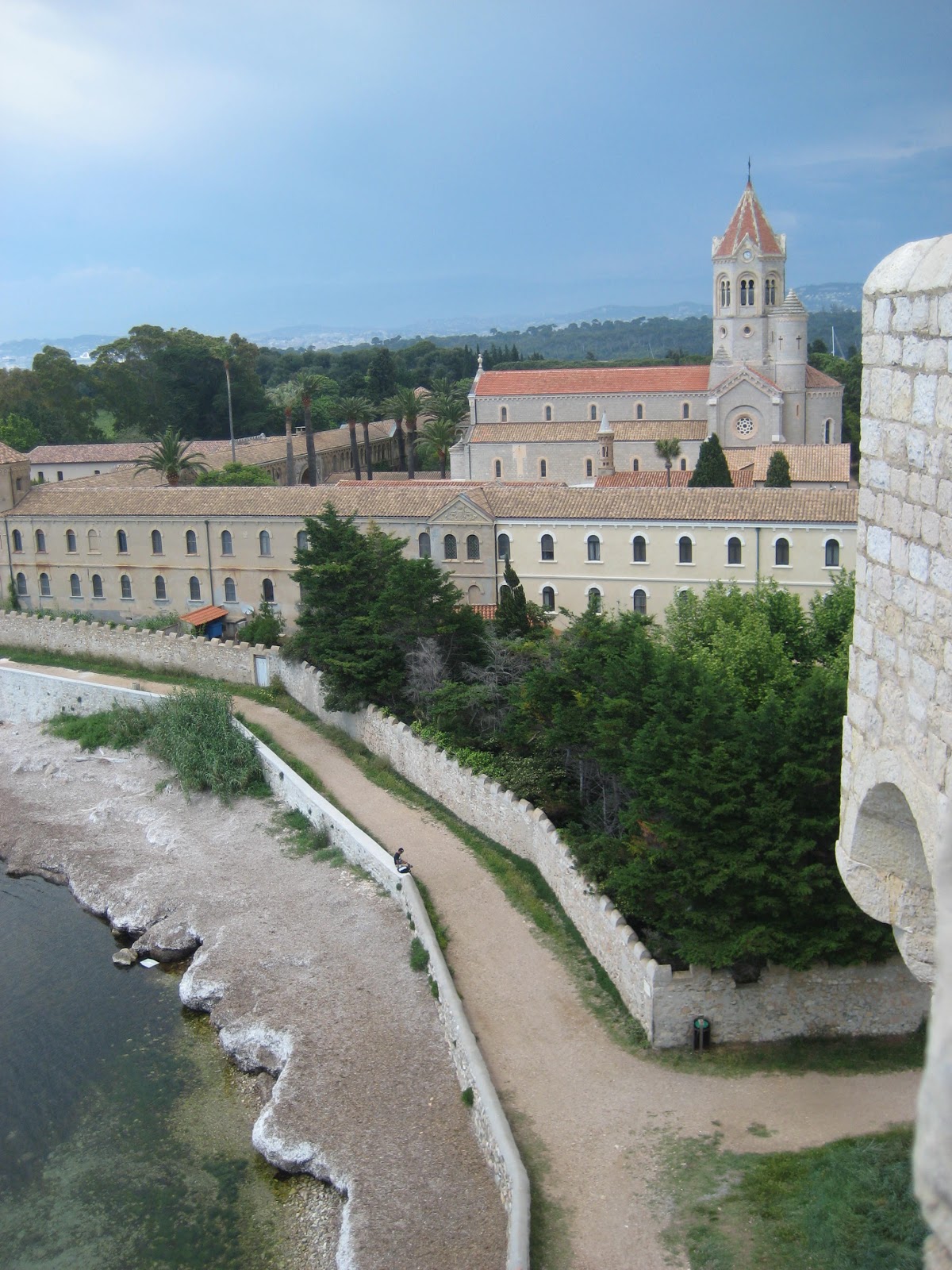
At 2:00 pm we boarded the "St. Honorat III," the ferry boat that took us to the island of Saint Honorat.  After a twenty-minute boat ride, we immediately went to the fortified monastery on the southern coast.  Dr. O'Brien explained the history then we were sent off to explore.


Again, the views of the sea were amazing.  Not a bad view no matter what direction you pointed the camera.    A beautiful place to relax and recharge.  Also a very strategic place to build a fortification - you can see a ship coming miles away!

I like capturing views framed by gaps in the stone

Coast and the modern Abby of Lerins


View of the Sea

Minda, Jim, Cullen, and Erica enjoying the view above.

After our time in the fortified ruins, we headed to the active part of the island - the LĂ©rins Abbey.  As the church was empty at that moment, we were able to spend a little time in it.  It was very plain and simple compared to the other churches we had seen up to that point.  We then wandered back toward the north side of the island where we would meet the ferry to go back to the main land.  As it had started to rain, we gathered at the resturant for a drink before heading back to the mainland.  

Jim (on left) with best glass of wine ever

Jim thoroughly enjoyed is 9 Euro glass of wine - he didn't know it was going to be that expensive when he ordered it.  (Just a note, on average we were paying 2-5 Euros for an entire bottle of wine)  Note to self - always check prices, don't order without seeing the wine list.  We caught the ferry at 5:00 pm and once on the mainland it took forever (over an hour) to get out of Cannes due to the festival traffic.  Dinner back in Vergons at about 8:00 pm then back to the gite for journaling.


For additional pictures on Saint Honorat go here.


Wednesday, October 17, 2012

Antibes

Friday 25 May 2012

Early morning again - on the bus by 8:30 am for our two hour drive to Antibes along the coast.  The nice part was I slept most of the way there. :)  We were dropped off by the pier and walked  to the market to check things out.   It was much larger (and more expensive) than the last market we were at.  Everything from fruit and veggies to meats and cheese all under one large pavilion.


Following the market, we walked the ramparts.  Absolutely beautiful views of the sea from this part of the city.


In exploring the rest of the city - we stumbled upon this unique monument.  It was titled "1940-1945 Antibes a la Resistance et ses Martyrs"  What was different about this monument from others I had seen was the look as if the figure was carrying a heavy load on his shoulders.  Was he weary with the weight of sorrow or was it something else?


With our limited time in Antibes, we saw what was left of a Roman cistern we had missed on the rampart and caught some lunch before boarding the bus at 12:30 to take us to our next destination - Cannes and the Isle of Saint Honorat.

For additional photos in Antibes go here.

Friday, August 17, 2012

Olives

Thursday 24 May 2012

An early start to the day - we had to catch the bus at 8:30 a.m.  We drove about an hour and a half to tour  Moulin des Penitents Olive Oil Mill.  When we were almost there, we stopped at a rest stop and saw the  Les Rochers Des Mees - a series of rocks that look like penitent monks.  Legend has it they were the monks of the Lure mountain who were petrified by Saint Donat during the Saracen invasions as punishment because they fell in love with the beautiful young women that were brought back from a crusade.

In front of Les Rochers
When we arrived at Mouin des Penitents, the first then we did was take a tour of the olive orchard/grove.  These farms have some trees that are up to eight hundred years old!  They used to have more trees of that age, but a bad frost hit the area in the 1930s, killing many of them.  

800 Year Old Olive Tree


Look closely to see the little flower blooms - they are not quite ready just yet


Did you know that bees do not pollinate olive flowers?  The flowers are actually too small and instead they have to rely on the wind for pollination.


I enjoyed wandering through the grove.  When we finished we headed back to the shop and saw the traditional equipment used to press the olives to make olive oil.  Then we were able to head to the factory and see how it is done today - in a state of the art press!  They are even able to use some of the byproduct to fuel the heating system in the building - very eco-friendly.

One of the machines used.

Following our tour of the factory, we headed to the city of Digne les Bains.  We found a great pizza place - too much food!  Mine had a paper napkin attached to the bottom, that was interesting.  It's a good think I mostly finished what I was going to eat before making that little discovery.  Minda needed to find a pharmacy in order to get some motion sickness medication.  I still am so proud of myself for successfully asking for it in French.  The pharmacist spoke really good English, so we finished out the conversation that way, but it was still good.

WWI Memorial
Of course no city trip is complete without finding the WWI Memorial.  This was the first one that I saw that was more than just a pilliar.  The woman represents France, she is holding a wounded/dying soldier and I believe she is standing on top of an Eagle, which probably represents Germany.  Fascinating!


Shortly after leaving Digne les Bains, we stopped to see a large wall of sea creature fossils - way cool!


Closer to Vergons, we stopped at another memorial.  This time for eleven men who were shot by the Germans during WWII for being a part of the resistance.


The rest of the evening was Boule, than an amazing dinner of ravioli that no one could finish.  Not for lack of trying, it was really, really good!

Winning Boule team of Minda, Erica, and Tim
Winning Boule team of Cullen, Nathan, and myself


For more pictures of the day go here.


Friday, August 3, 2012

Castellane

Wednesday 23 May 2012 Continued

Street in Castellane
Apparently our geocaching detour only took twenty minutes longer than the rest of the group that was exploring the ruins.  We were even able to find them at a restaurant and get a table nearby.  We all went for the plat du jour (plate of the day), which consisted of chicken, fries, and veggies in a sweet sauce.  All but the fries being a dish special to the region.  It was fabulous!  

My cat, Harvey's, French Doppelganger


Notice Notre-Dame du Roc in the background


Following lunch, we wandered as a group, checking out all the little shops.  They were full of regional pride - lavender, olive oil, etc.  We found the main church and continued to wander around town.


We also checked out the river, which flows at the base of the large rock that has Chapelle Notre-Dame-du-Roc at the top


Tourist and Game Store


I was able to pick up a boule set at one of the shops.  A cheap tourist set, but it will still work.  What can you expect for 14,80E?  I'll get teased by any real boule players for having a set of chocolate balls, but I won't find many real boule players back home, will I?


Of course our visit would not be compete without finding the memorial to the WWI dead.  Following our examination, we headed back to the main square and had a penache - a beer mixed with lemon-flavored soda with Dr. Wingerd.  Thankfully the bus arrive thirty-minutes early as the rain was moving in.


We left Castellane and stopped by the dam at the head of the gorges.  We got caught in the rain, so we did not stay long, but it was still neat to see.  Then it was back to Vergons for dinner and another round of class before turning in.  The sunset was absolutely amazing!


Tim, Erica, Bryce, David, and Cullen


For more pictures of our day in Castellane go here.


Thursday, August 2, 2012

Chapelle Notre-Dame-du-Roc

Wednesday 23 May 2012

We had a bit of a lazy morning - didn't have to board the bus until 10:00 am to head to Castellane, about a 20 minute drive from Vergons.  Castellane is just south of Lac de Castellion and at one end of Gorges du Verdon, which we'd see later.  

The first thing we did after arriving is explore the market.  It was small as we were early in the season, before most fruits and veggies are available.  However, there was plenty of the typical foods of the region - i.e. wine, cheese, sausages, and some fruit.  Michel helped Tim and me find some good cheese.  25e. later we had my contribution to the gite's supply of food.  The vendor even threw in some garlic sassage.  I believe the cheese was Beaufort Cheese - it was really good!

Following our time in the market, we began the trek up the small mountain to the Chapelle Notre-Dame-du-Roc (Our Lady of the Rock).  This would make three hikes up small mountains in as many days.  I was sore, but it was well worth it.  Breathing in the altitude while hiking was the hardest part.  

Chapelle Notre-Dame-du-Roc

One of the stations


As climbed the stone stair trail/road there were a few markers for saints, and then the Stations of the Cross were available for those making a pilgrimage.  If I would have been by myself, I would have made the climb a pilgrimage and participated in the stations, but as it was, we just kept climbing to the top.  It seems highly appropriate to make the difficult journey to the top a pilgrimage.  His suffering united with the suffering of those making the challenging climb.  I knew there were still people using this as a pilgrimage as there were flowers left at some of the stations.


View of Castellane from about half way up


The higher we climbed, the more the spectacular the view.  The day was clear and we could see for miles.Chapelle Notre-Dame du Roc was a spectacular commemoration to Mary.  The entire interior was completely covered with paintings, plaques, and statues.  I did not want to use my flash, so of course none of my pictures really turned out as it was so dark inside.  I could have sat in there for hours just soaking everything in.


Chapelle Notre-Dame-du-Rock


After  exploring for a while, I decided to check the area for a geocache - if I was going to place one, it would be near the top of the rock.  Sure enough there was one in the city - GC1WTZR - it actually started down below, but lucky for me it sent cachers up to the chapel.  At the chapel we (David and myself) attempted to answer questions, such as dates of paintings, year of the city, height of the rock, etc.  We needed these to do some calculations on where the final container was going to be.  Once we thought we had the correct coordinates, we rejoined Bryce, who was guarding packs while we flitted about getting information, and set off.


According to our calculations, the cache should have been .6 mile toward the ruins.  Awesome - this was the direction we wanted to go anyways as this is where all the others in our group headed earlier.  We followed the "Tour de Roc" path and found a large stone wall from about the 9th C. building.  After exploring it we continued down the trail.  The GPS said the geocache was straight ahead.  However instead of the trail continuing to go straight, it began to head down the mountain, taking us away from the cache.  


Cullen, Nathan, Bryce, Muaamar, me, and David


Typical Geocaching Adventure


As we did not have a trail map, we continued along the way, hoping that it would turn back to the direction we needed.  But as we dropped down below the arid tree line along a mountain creek into woods that felt very much like Minnesota (minus the killer mosquitoes) we just kept heading down, down, down.  With the recent rains the trail was muddy and a little slick.  The creek was high in some spots, but we made it through without falling in the mud! (A huge bonus for me as many know of my ability to fall on flat ground.)  

When we reached a road at the bottom, we were still .4 mile away and we decided to give up and return to the top. Apparently I cannot read in French as well as I thought I could and must have gotten a wrong number in the coordinates.  Oh well, the journey is the best part of the adventure!  


We re-climbed the mountain - me waking through the creek instead of trying to hop over.  I was wearing my chacos, so it didn't matter if my feet got wet.  Bryce managed to hop over, but David took off his shoes and socks and waded right on through, washing his feet off on the other side.  When we finally reached the top again, we tried once more to find a path to the cache, but the only other path lead straight into a brier patch.  I'd had enough fun by that point, and officially gave up and headed back to the city of Castellane.

More about Castellane in my next post.
As always for more photographs go here.


Tuesday, July 24, 2012

Geocaching!

Tues 22 May 2012 continued


Sheep outside of Vergons

After descending from the mountain, Bryce, David and I made a quick pit stop at the gite before continuing on to Notre-Dame-de-Valvert, a church on the outskirts of Vergons.  As we were leaving the village to head up the road, we saw one of the local farmers with his sheep across the road.  Bryce got a little excited - as his chapter for Dr. Wingerd's class was all about the animals of France and it talked about taking sheep from one part of the mountains to another.


Cemetery at Notre-Dame-de-Valvert


The church was all made of stone, with a stone wall surrounding the cemetery.  Right in front, surrounded by a wrought iron fence as the memorial to the war dead, Paul Simon included.


Interior Alter


The interior of the church was very dark - as the stone structure had few interior windows.  It was, after all, a medieval fortified church.  Originally the village of Vergons was much closer to this church, but it was destroyed by a landslide and those who survived relocated the village to its current location.


After talking about geocaching for a few days - annoying some and intriguing others - I finally had the opportunity to introduce Bryce and David to the game.  GC1WENW Vergones - Notre Dame de Valvert was located somewhere on the grounds.  I went and found the cache when the guys explored the cemetery.  Once I found it, I got them to ground zero and made them hunt for it themselves. 


The geocache is in this picture - can you find it?


Bryce has good geosence and walked straight to it. The pressure's off - I found one cache in France and any others are a wonderful bonus.  We each signed the log and put it back in its hiding place.  Too bad the container was too small for me to put my geocoin in.  Perhaps the next one will be better. 

Michel and me with our winning score


We walked back to the gite, worked on some homework for a while.  Bryce noticed that sometime in the next couple of days we were to have a Boule tournament, so I suggested that we go and practice.  It was a close game - Michel and I with a final score of 13 and Bryce and David with 11.  We're improving, but I know I still need more practice.


The rest of the evening consisted of dinner and more homework/hanging out at the gite.  For more pictures of the day go here.

Thursday, July 12, 2012

Hiking Le Chamatte

Tuesday 22 May 2012

Thankfully Tim woke me up this morning - otherwise I would have been late for class.  We finished discussing Becoming Roman and got a few more chapters accomplished in The Discovery of France.  Not bad for what was supposed to be our free day.  Our free day came earlier than planned, as the weather was not the most cooperative for touring the Gorges of Verdon, so we swapped a few things around with the hope for better weather later in the week.

Following class, several of us grabbed lunch at the local resturant, named Le Chamatte after the mountain, and then we got ready to go for a hike up the mountain near Vergons.  Dr. O'Brien and Michel lead the way.

Heading up the mountain.  The village of Vergons is in the background.

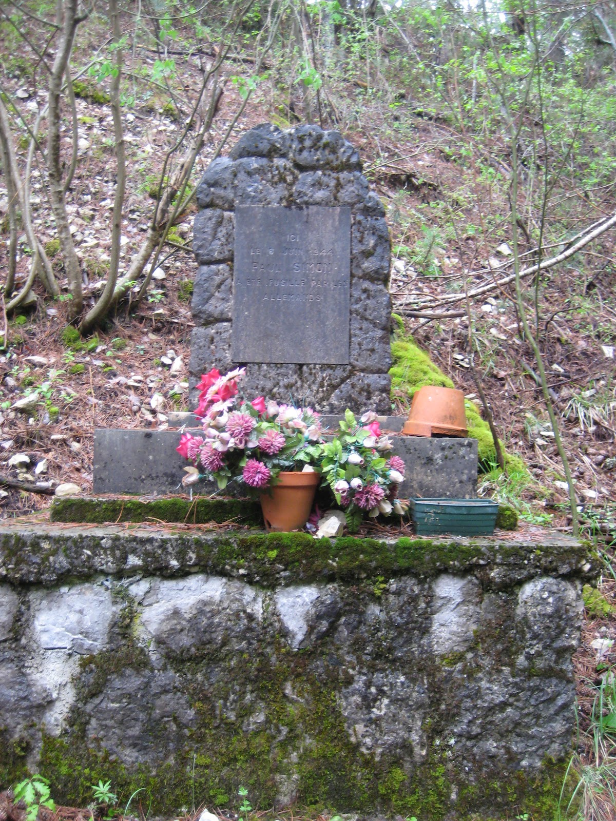
Marker for Paul Simon


Our first stop along the way was at a memorial dedicated to a man named Paul Simon.  He was shot by the Germans in June 1944 at this location, as he was hiding outside of town when they came through the area during WWII.  It is unsure why he was there in the first place.  Perhaps he was part of the Resistance, perhaps he had other reasons.


Me with a view of the valley

A view of the village of Vergons


From this point, some in our group turned back to town, while the rest of us continued onward and upward.  Our destination was a hunting shack located about a third of the way up the mountain.


So many amazing views were to be had as we continued onward and upward.


David and Bryce making the final approach

It was such a great feeling to reach the hunting shack and see how small Vergons was below.  Dr. O'Brien had fun showing us the rustic outhouse (see picture below).  You know you are in a remote location when the "house" part of the outhouse is nonexistant!

The best view of them all
While we were tinkering around Bryce and David went to see where the rock-slide happened.  Then the three of us descended much quicker than it too us to make the climb.  We wanted to see Notre-Dame-de Valvert and I wanted to find a geocache - more on that adventure in my next post. :)

View of the mountain

Looking back up at the mountain, it is amazing to think how far up we really were.  I wish I could point it out to you in the photograph, but I really have no idea where we were :)

For more pictures go here.